Search
Now showing items 1-5 of 5
OVSICORI's Southern Costa Rica Geodynamic Control Network: The opening of a Pandora's Box
(IASPEI, 2016-06-20)
Summary of the presentation “OVSICORI's South Costa Rica Geodynamic Control Network: Opening a Pandora's box. Presented at II General Assembly of the Latin America and Caribbean Seismological Commission of IASPEI, Heredia, ...

Far-field triggering of foreshocks near the nucleation zone of the 5 September 2012 (MW 7.6) Nicoya Peninsula, Costa Rica earthquak
(Elsevier, 2015-12-01)
On 5 September 2012, a moment magnitude (MW) 7.6 earthquake occurred directly beneath the Nicoya Peninsula, an area with dense seismic and geodetic network coverage. The mainshock ruptured a portion of a previously identified ...

A brittle failure model for long-period seismic events recorded at Turrialba Volcano, Costa Rica
(American Geophysical Union, 2015-01-30)
A temporary seismic network, consisting of 23 broadband and six short-period stations, wasinstalled in a dense network at Turrialba Volcano, Costa Rica, between 8 March and 4 May 2011. During thistime 513 long-period (LP) ...
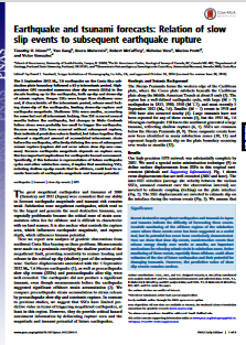
Earthquake and tsunami forecasts: Relation of slow slip events to subsequent earthquake rupture
(National Academy of Sciences, 2014-11-17)
The 5 September 2012 Mw 7.6 earthquake on the Costa Rica subduction plate boundary followed a 62-y interseismic period. Highprecision GPS recorded numerous slow slip events (SSEs) in the decade leading up to the earthquake, ...
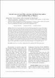
Isla del Coco, on Cocos Plate, converges with Isla de San Andrés, on the Caribbean Plate, at 78mm/yr
(Revista de Biologia Tropical, 2012-11)
Isla del Coco is the only land mass of the Cocos Plate that emerges above sea level. This makes it the only place where Cocos Plate motion can be measured using Global Navigation Satellite System (GNSS) monitoring. Global ...